Statistical treasure trove
The charts and maps can be set for specific areas. The underlying database figures are also provided.
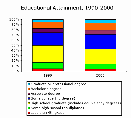
Tacoma, Washington:
CHARTS & TRENDS
"Census 2000 and Trend Data going back to 1990, 1980, and sometimes even further, on a growing list of topics, including population growth, population by race, age structure, family structure, and income."
MAPS
"Many of the most important social trends affecting America have a strongly regional flavor. Figure out where you fit in with demographic maps showing where the elderly predominate (think: the Great Plains), where the nuclear family is (and isn't) the norm, and how "diversity" breaks down regionally."
RANKINGS
"State and county-level rankings by population growth, race, educational attainment, language, gender, and more."
SEGREGATION
"Segregation Exposure and Dissimilarity Measures for 1246 individual US cities with population exceeding 25,000 and for all metropolitan areas, based on single and multiple race populations as identified in Census 2000."
CensusScope
University of Michigan:
Social Science Data Analysis Network
The site was suggested by the eclectic J-WalkBlog of John Walkenbach.
See all Topics
No comments:
Post a Comment